
Nearly 400 Acres of Wildlife Habitat Will Be Destroyed … Unless We Stop It
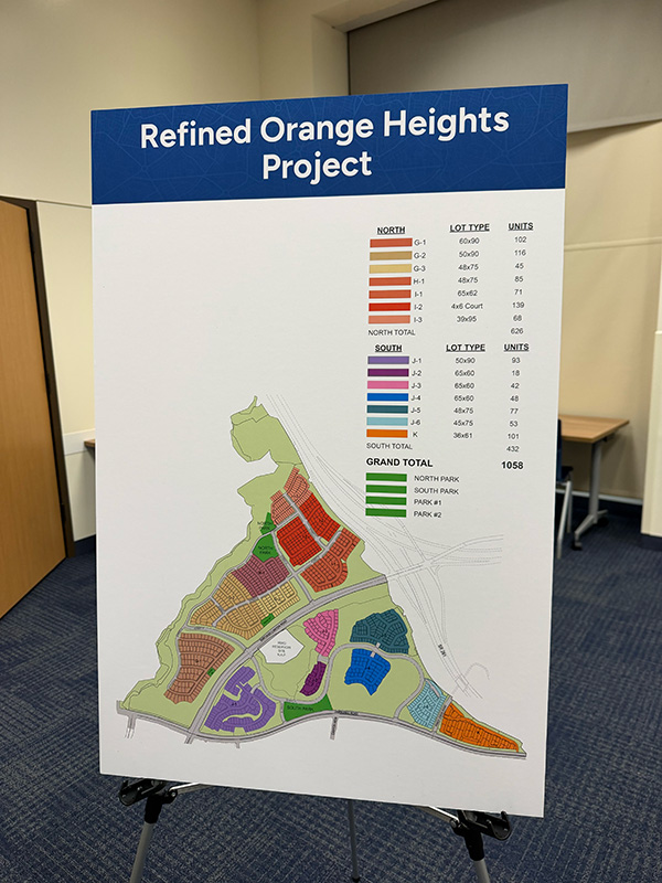
The Irvine Company wants to build 1058 residential lots that would destroy 396 acres of open space — while providing virtually no fiscal benefits to the City of Orange or to the County of Orange. Here’s a better idea: let’s preserve this land instead.
Orange Hills Vision
Our vision is to protect this land from development and preserve it as a regional park. Saving this land, by connecting Irvine and Peters Canyon Regional Parks, will create 1,245 contiguous acres of parkland, preserving wildlife corridors and creating new ones for people.
This is not just about stopping 1,058 houses; it’s about safeguarding a living legacy of biodiversity, history, and access to nature for generations to come.
A Park with Purpose
Our vision for Orange Hills Regional Park goes beyond preservation—it’s a bold, regenerative plan to reconnect ecosystems, protect sacred lands, and create a vibrant space for people and wildlife alike.
Biological Connectivity
Allow mule deer to return to Peters Canyon Regional Park. Reduce roadkill by creating and enhancing wildlife crossing infrastructure to allow for safe passage between Irvine Regional Park and Peters Canyon Regional Park. Expand or modify existing drainage culverts and construct vegetated overpasses to serve mule deer, mountain lion, bobcat, coyote, gray fox, spotted skunk and various other wildlife species who risk their lives trying to cross under or over Santiago Canyon Rd and Jamboree Rd.
Wildfire Buffer with Habitat Restoration & Fire Resiliency
Create irrigated “green zones” by restoring the native plant communities along Jamboree Rd and Santiago Canyon Rd to increase habitat for declining special status species, including coastal cactus wren and Blainville’s horned lizard and increase soil and vegetation moisture levels as a wildfire buffer for adjacent residential communities.
Public Access, Trail Connectivity & Education
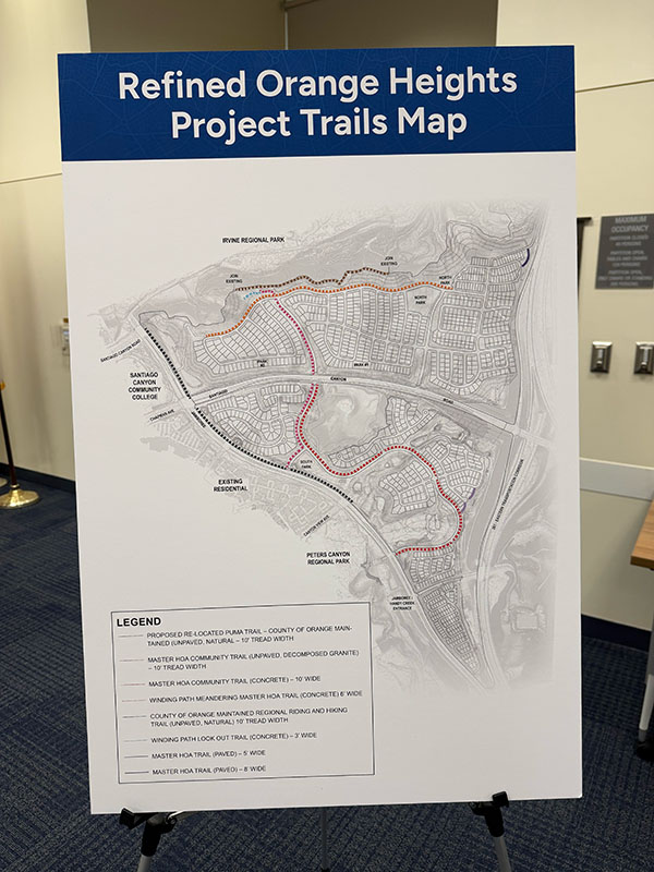
Develop an interconnected trail network utilizing the wildlife crossings, so hikers, mountain bikers and equestrians can travel between Irvine Regional Park and Peters Canyon without having to step foot on Santiago Canyon Rd or Jamboree Rd. Offer educational programs, including guided interpretive walks and rides that focus on natural and cultural history.
Cultural Resource Preservation
The Orange Hills are considered an Indigenous cultural landscape and culturally sensitive area by the Tongva Gabrieleño, Kizh Nation and Acjachemen Juaneño. Protect and preserve CA-ORA-556, a prehistoric Native American village site that is eligible for California register of historic resources, with permanent access for tribal gathering and archaeological research.
A Park with Purpose

Orange Hills Regional Park Conceptual Site Plan. Click on the image to enlarge. Note: All items shown are conceptual and subject to further study.


Proposed Orange Hills Regional Park
Website
Map
Brochure


Proposed Orange Hills Regional Park
Website
Map
Brochure
Saving Orange Hills will:
Reduce Traffic Congestion
Rejecting this project will effectively reduce daily vehicle trips on local area roads such as Jamboree and Chapman/Santiago Canyon. There is no compelling reason to add traffic to these already clogged local roads, especially for a project with no substantial benefits for either the City of Orange or the County of Orange.
Increase Open Space & Connectivity

Saving Orange Hills will not only save nearly 400 precious acres of open space, it will — by connecting Irvine Regional Park and Peters Canyon Regional Park — establish a new public park area of 1,245 contiguous acres.
Reduce Fire Risk

This is a Very High Fire Hazard Severity Zone. The 2017 Canyon 2 Fire destroyed 9217 acres. Preventing new homes in this area would keep residents, emergency responders, and pets out of harm’s way.
Donate Today!
Your financial contribution to stopping the Orange Heights development and Saving Orange Hills is crucial. All donations to Save Orange Hills are processed through our fiscal sponsor, Naturalist For You, a 501(c)(3) environmental education non-profit. If you prefer to give by check, please make your check payable to “Naturalist For You” and mail to Naturalist For You, P.O. Box 381, Silverado, CA, 92676. Ask your employer about matching donations. All donations are tax-deductible. Tax ID: 20-8247602. Thank you for your support!
Make a Credit Card or Bank Transfer Donation Here Without transaction Fees
Take Action
Orange Heights Development Project Public Notice
We had a FANTASTIC outpouring of comments during the public scoping period for the latest Supplemental Environmental Impact Report for the “Refined Orange Heights Project”. This was our first opportunity to create a legal record of public feedback since this latest construction push, and we were overwhelmed by how well our supporters delivered. The fight is just beginning.
NEXT STEPS:
Please send your mailing address and phone number to Hayden Beckman at the City of Orange (hbeckman@cityoforange.org), with a request to be added to the notification list for the Orange Heights project.
Click Here to Send an Email
(remember to include your full name, mailing address, phone number, and email address)
Make sure to follow our newsletter and social media updates to keep the pressure on The City of Orange and The Irvine Company!
Volunteer Opportunities


The planned Orange Heights development project will impact all of us — threatening a vital wildlife corridor and wildfire buffer zone. But your involvement can make a real difference.
We need you to attend and speak at public meetings and help with community outreach, fundraising, events, marketing, citizen science, volunteer recruitment, and other operational tasks.
Thank you!
Fill out the form to help with outreach, attend and speak at public hearings, raise funds and other volunteer actions.
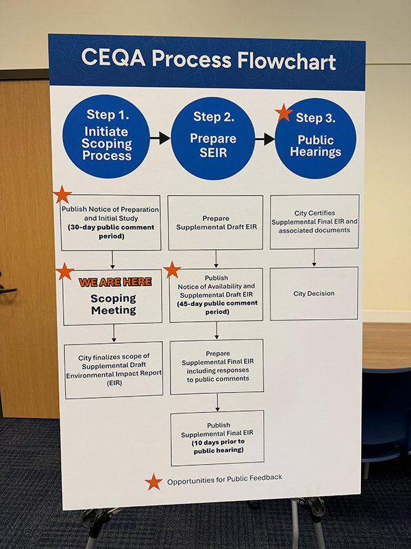
Public Hearings
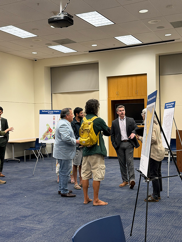
Thank you to everyone who showed up to the public scoping meeting at the Orange Public Library on Tuesday, May 5th!
We had 57 attendees who were able to ask questions, share concerns, and submit comments to the Orange planning staff!
Posters showed how expansive the development project was planned over the Orange Hills. Staff were available to answer questions.
This is the beginning of a process that will eventually lead to the circulation of a draft SEIR, either late this year or early next year, when the public will have a final opportunity to speak and submit comments to the Orange planning commission and city council about the project’s environmental impacts and whether or not it should be approved.
Based on the findings of the Initial Study, implementation of the Refined Orange Heights Project may result in significant environmental effects related to the following topical issues. These topical issues will be evaluated further in the SEIR and will be compared to the impacts of the Approved Santiago Hills II Project from 2005.
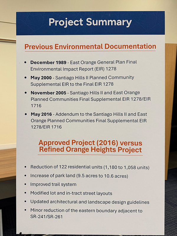
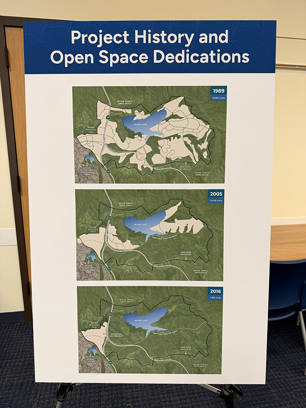
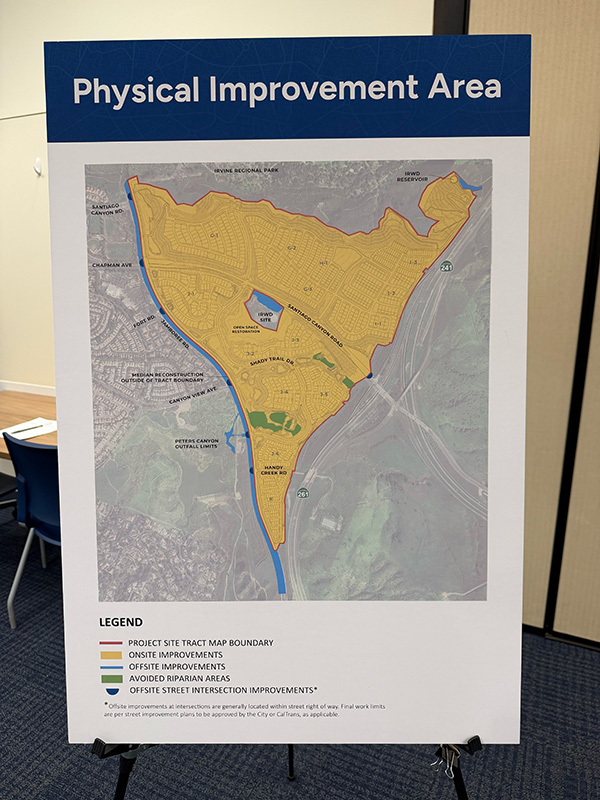
Orange Heights Project Plan


Never doubt that a small group of thoughtful, committed citizens can change the world; indeed, it is the only thing that ever has.
~Margaret Mead
A Look at the Numbers
Roughly 400 Acres of wildlife habitat will be destroyed. This area is home to endangered wildlife, including mountain lions, Crotch’s bumble bee, Bell’s vireo, coastal California gnatcatcher, the white-tailed kite, and other species.
1058 single-family homes are proposed to be built on this site, increasing the traffic congestion in an already congested area and contributing to urban sprawl, contrary to the stated goals of the City of Orange.
1,245 uninterrupted acres of parkland will be created by linking — using connectors for both wildlife and people — Irvine and Peters Canyon Regional Parks. This connected landscape will safeguard wildlife corridors, preserve a wildfire buffer, and provide lasting recreational space for the community.
More than 27,000 people have signed our petition to stop the Orange Heights project from moving forward. Can we count on your support? Visit our Petition site to add your name to our cause. Every person’s voice matters!
Cultural Resources

The Orange Hills are a place where wolves once hunted pronghorn, and the Tongva and Acjachemen people thrived for thousands of years. Hidden amongst the vegetation and soil lies a prehistoric Native American village site, known as CA-ORA-556, which qualifies for the California Register of Historical Resources. The site is considered a unique archaeological resource for the purposes of the California Environmental Quality Act, thereby contributing an ancient cultural foundation to the heritage of Irvine Regional Park, our state’s oldest regional park.

This projectile point is 1 of 635 stone artifacts recovered from CA-ORA-556 during the construction of Jamboree Road in 1989.
Fire Hazard Severity = Very High

The geographic center of the proposed Orange Heights project is located in a Very High Fire Hazard Severity Zone (FHSZ), as recommended by the State Fire Marshal in 2025.
Learn more about the CalFire FHSZ assessment here.
Upcoming Walks, Hikes & Biosurveys

No Events Found
Save Orange Hills Brochures
There are 2 different brochures available for download below. There are English and Spanish versions for each brochure.
Hay 2 folletos diferentes disponibles para descargar a continuación. Hay versiones en inglés y en español para cada folleto.
4-Panel Brochure - Outside

4-Panel Brochure - Inside

3-Panel Brochure - Outside

3-Panel Brochure - Inside

Fundraiser
Support the Fight to Save Orange Hills!
All proceeds from these incredible donations go directly to funding Save Orange Hills operations and land preservation efforts. If you are interested in any of the items below, please contact info@saveorangehills.org or text 714-798-4392 to arrange for the purchase.


Letters from Supporting Organizations

Shute, Mihaly & Weinberger

Center for Biological Diversity

Channel Law Group

San Gabriel Band of Mission Indians

Native Plant Society
Everyday Citizens, Extraodinary Wins

When it comes to protecting the places we love, history shows that everyday citizens can make a difference. From the coastal bluffs of Crystal Cove to the wild heart of Laguna Canyon, communities across Orange County have successfully challenged powerful developers, including the Irvine Company, and turned threatened land into lasting public parks and preserves. These inspiring victories remind us that with vision, persistence, and collective action, we can protect Orange Hills and leave a legacy of open space, wildlife, and natural beauty for future generations.
Upper Newport Bay

The Story of Upper Newport Bay
In the early 1960s, the Irvine Company and Orange County officials pursued a plan to transform Upper Newport Bay into a sprawling marina with private docks, homes, and recreational developments. To make this possible, a controversial land swap was proposed: the County would trade publicly owned tidelands for blufftop land held by the Irvine Company. The Board of Supervisors approved the deal in 1965, paving the way for what many assumed would be an irreversible transformation of the Bay.
But a small group of concerned residents had a different vision. Frank and Frances “Fran” Robinson, along with other grassroots activists, began organizing to protect the Bay’s rich wetland habitat. They helped found Friends of Newport Bay (FONB) in 1967, a pioneering environmental group that combined community organizing with educational tours to raise awareness about the ecological value of the area. Despite being environmental underdogs in a developer-dominated era, the group filed a legal challenge to the land swap in 1969, questioning its constitutionality.
The court battles, coupled with growing public awareness and media coverage, created a groundswell of support for preserving the Bay. In 1971, the land exchange was finally canceled. By 1975—after more than a decade of advocacy—the Upper Newport Bay Ecological Reserve was officially established and dedicated “in the name of the people of the State of California.” Additional land was later added to the reserve, including the Big Canyon area (1982) and 140 acres of surrounding bluffs (1990), now managed as the Upper Newport Bay Nature Preserve by Orange County Parks.
Today, Upper Newport Bay is one of the largest remaining natural estuaries in Southern California, supporting thousands of migratory birds and rare wetland species. None of this would exist without the courage and perseverance of local citizens who believed the Bay should belong to everyone—not just developers.
Learn more:
Laguna Canyon Wilderness Park

The Story of Laguna Canyon Wilderness Park
Laguna Canyon, a stunning stretch of coastal wildlands nestled between Laguna Beach and the inland suburbs, became the center of one of Orange County’s most iconic land preservation battles. In the 1980s, the Irvine Company had secured county approval to develop Laguna Laurel, a master-planned community of 3,200 homes, commercial buildings, and a shopping mall—right in the heart of the canyon. But artists, residents, and environmentalists saw the canyon as sacred, wild, and worth fighting for.
Among the most powerful expressions of protest was “The Tell,” a 636-foot-long mural composed of thousands of donated photographs from Orange County residents, capturing their memories of Laguna Canyon. Created by artist Mark Chamberlain and The Laguna Canyon Project, the mural became both a symbol of the community’s connection to the land and a rallying point for collective action. On November 11, 1989, nearly 11,000 people marched into the canyon, staging one of the largest environmental demonstrations in Orange County history.
What followed was a rare collaboration between former adversaries. The Irvine Company, environmental groups like the Sierra Club and Audubon Society, local governments, and community leaders entered into facilitated negotiations. After months of dialogue, the parties reached a historic agreement: the Irvine Company would sell the disputed land for permanent conservation, at a discounted rate. A successful property tax bond campaign, which passed with 79.7% of the vote, helped fund the acquisition.
By 1993, the land was officially protected as Laguna Canyon Wilderness Park, part of the 22,000-acre South Coast Wilderness—now the second-largest urban wilderness greenbelt in the U.S. What could have been just another suburban sprawl became a national example of how grassroots advocacy, creative protest, and unlikely partnerships can preserve the wild heart of a region.
Learn more:
Crystal Cove State Park

The Story of Crystal Cove State Park
In 1976, newly transplanted Newport Beach realtor Jean “Pirkle” Jones founded Friends of the Newport Coast, setting her sights on what many viewed as an impossible task: stopping the Irvine Company from transforming nearly 10,000 acres of pristine coastal land into a dense development of homes, high-rises, and roads. The proposed project would have dramatically altered the hillsides and bluffs overlooking the Pacific between Corona del Mar and Laguna Beach.
From the beginning, the battle seemed one-sided. The Irvine Company—led by real estate mogul Don Bren—was one of the largest landowners in California and wielded enormous influence in Orange County. But Pirkle and her allies refused to back down. Through years of legal action, community organizing, and environmental advocacy, the Friends of the Newport Coast challenged every stage of the development process. They pushed for lower housing density, fought against high-rise commercial buildings, and insisted on permanent protection for open space.
Their persistence paid off. In 1981, the State of California purchased 2,807 acres of the Irvine Coast for $32.5 million, the most expensive state parkland acquisition in California’s history at the time. That land became the core of Crystal Cove State Park, protecting miles of coastline, inland trails, and coastal sage habitat for generations to come. The lawsuit also succeeded in scaling back the remaining development, limiting it to 2,600 homes and preserving nearly 80% of the area as open space and wildlife habitat.
Pirkle’s legacy lives on every time someone hikes the ridgelines, explores tidepools, or camps under the stars at Crystal Cove—a park that wouldn’t exist if ordinary people hadn’t dared to take on extraordinary odds.
Learn more:
Banning Ranch/Randall Preserve

The Story of Banning Ranch
Banning Ranch, a 401-acre expanse of coastal bluffs, wetlands, and oil field habitat at the mouth of the Santa Ana River in Newport Beach, was the last large piece of unprotected open space along the Southern California coast. Since the late 1990s, it was the focus of intense development pressure. In 1999, Taylor Woodrow proposed 1,750 homes for the site. By 2008, Newport Banning Ranch LLC (NBR) put forward an even more ambitious plan: 1,375 homes, a resort hotel, and 75,000 square feet of commercial space.
When the City of Newport Beach approved the project in 2012, local residents, environmental advocates, and tribal representatives—united under the Banning Ranch Conservancy (BRC)—filed suit. Their case moved through multiple appeals over several years. In a landmark 2017 decision, the California Supreme Court ruled in favor of the BRC, affirming that the development violated the California Environmental Quality Act and setting a major precedent for how sensitive coastal lands must be reviewed and protected.
The court victory was only the beginning. In the years that followed, BRC collaborated with The Trust for Public Landto pursue permanent protection for the site. In 2020, philanthropists Frank and Joan Randall stepped forward with an extraordinary $50 million private donation to help purchase the land for conservation. Additional public funding brought the total to $97 million, enabling the full acquisition.
Now known as the Randall Preserve, Banning Ranch is being restored as a vibrant public space that will offer trails, coastal habitat, tribal access, and environmental education. It stands as a powerful reminder that community determination, legal advocacy, and philanthropy can unite to protect what matters most.
Learn more:
